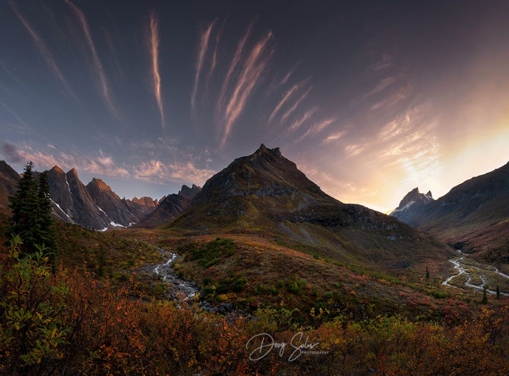
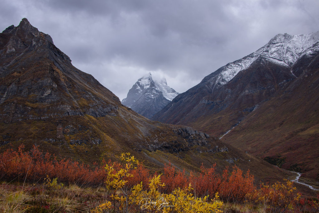
Landscape Photographers are constantly searching for new and exciting areas to capture those one of a kind shots or even searching out well seasoned locations and trying to put their own spin on it. The Arrigetch Peaks located in the Gates of the Arctic National Park, Alaska is definitely an exciting destination where you can get creative. Go in the Fall season around late August and catch the Tundra in its peak color display and you also have an excellent opportunity at shooting the Aurora as the Arrigetch Peaks lay right in the heart of the Aurora Band called the Auroral zone. If the weather is kind, you just might capture a few great shots for the tin.
This trip has been on my radar for two plus years and ranked up there pretty high on the bucket list just because it’s a very demanding adventure and with time marching on I felt I needed to get this two week backpacking/photography party started!
BACKGROUND INFO:
The Gates of the Arctic National Park is the Northern most National Park in the United States, comprised of 8.4 million acres it is also the 2nd largest National Park in the US. It truly is a vast and virtually untouched wilderness. Within the Park lie the peaks and spires of the Arrigetch, which are part of the Endicott Mountains, centered on the North and South Slopes of the Brooks Range in Alaska. If you compare this Park to say Yosemite which is approximately 760,000 acres and has over 4 million visitors each year, the Gate of the Arctic NP had approx. 11,000 visitors last year, in fact it’s the least visited park in the Country! Primarily because there are no roads into or out of the park, no designated trails, no established campsites, no infrastructure, no in-park services, the Bettles Ranger Station an hour float plane away is the closet park service.
The Pitch:
Even though two plus years is plenty of time to put this trip together, I still needed to gather all the logistical pieces, but just as important was finding 3 other fools willing to take the plunge with me. (BTW I will provide a list of links and sources used including prices paid and the end of the blog Part II)
So the first person I pitched was my good buddy and fellow hometown photographer Jeff Trouette, I told him; "We would be flying into Fairbanks Alaska followed by a 1 ½ hour bush plane flight into Bettles, Alaska and finally from Bettles a 1 hour float plane into the Alatna Valley where we would be dropped off on a tiny lake. It’s there we would start the backpacking phase up into the Arrigetch Peaks, which would entail 10 days of backpacking probably over 30+ miles." After hearing my pitch he said just four words to me; “When do we go”. That was fantastic! Now I just needed to get two more guys on board. So over the following 3 months I spoke with 17 friends pitching the trip and I summarily received 17 denials! What? I hadn’t been turned down that many times since my High School dating days. So faced with postponing the trip a year vs “Get-er-done”, we both decided we would go it alone. Yeah!
Planning:
For remote wilderness trips like this, the first thing I like to do is to review topo maps for the location of interest, I always use Caltopo.com , (This links to our original map from Arrigetch Peaks). Caltopo has the ability to build custom maps with layers that can be toggled on/off or modified whenever needed. From adding desired routes and waypoints or Slope Angle Shading (so you know the steepness of the given terrain). There are over 20 different types of maps you can use and modify from USGA to Forestry Service as well as historical maps.
I also view my destination on Google Earth Pro to get a feel for the land. They have a basic sunrise/sunset view that will give you an idea of where to place yourself on the dates you will be there. Finally I rely heavily on Photographers ephemeris and most recently Photopills which is extremely accurate to aid in forecasting the sunset/sunrise and Milky way rise and fall, as well as a real time projection of the day/night sky on your phone. Finally, if I have cell or internet services (we had neither) I’ll always check the weather using Weather.gov for hourly conditions including wind/rain, cloud cover and humidity. So suffice it to say every outing into the backcountry requires thorough planning, detailed lists, travel logistics, maps, etc.
The Adventure Begins:
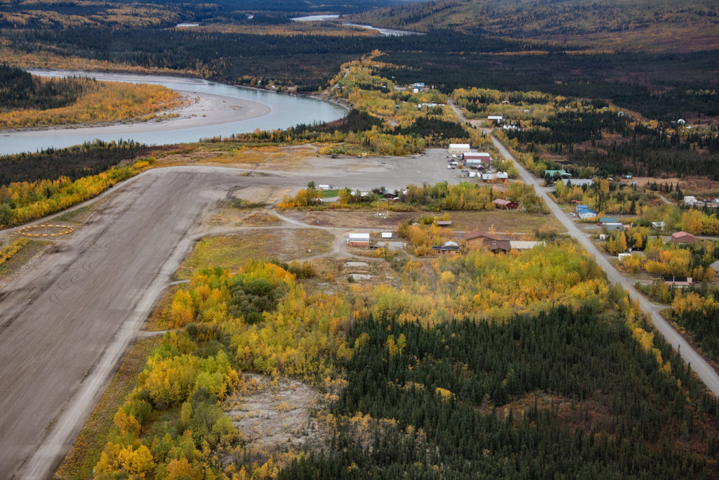
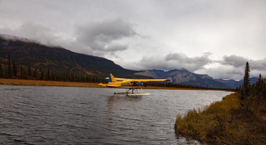
Our flight from Fairbanks to Bettles on Wright Air was about 1 ½ hours in a smallish 7 passenger bush plane. No other photographers were on board just hunters as the fall season was in full swing. We landed in Bettles, population 13; it does have one lodge appropriately called Bettles Lodge where they serve breakfast lunch and dinner for all. Also Brooks Range Aviation, (who provided our float plane services) has several very comfortable cabins as well (remember this is a remote location, so its “rustic comfort”). The main feature in Bettles is of course their gravel airstrip which was built during WWII and used now mainly for commercial and recreational purposes.
Because of our late afternoon arrival we planned on staying the night with Brooks Range Aviation, but that changed when one of the pilots recommended we fly out now because of a break in the weather around the Arrigetch and Alatna River Valley! I begged for an extra hour in order for us to unpack our suitcases and repack our backpacks, to which he smiled and said, "you best be ready in ½ hour"! So we jammed and crammed as efficiently as we could. We weighed our packs and found we needed to jettison a few luxury items in order to make weight (we needed to stay under 65lbs each), so my reading material and home-made cookies had to stay behind; survival was really going to be tough now!
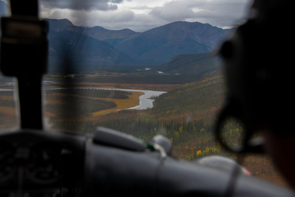
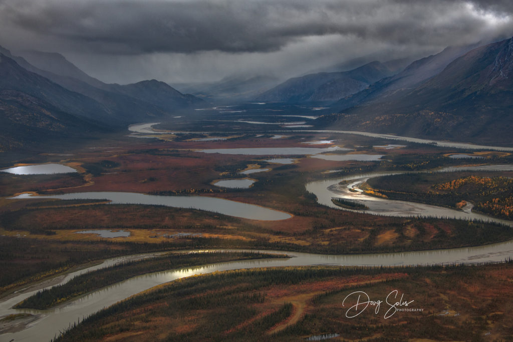
The float plane flight was blissfully uneventful, just the way I like them. Cloudy and raining but the ceiling was just high enough for our bush pilot to land us on a postage-stamp size pond (at least it appeared that way from 500 feet up) called Circle Lake. After unloading our gear we turned our attention to our pilot, our only lifeline to civilization, as he maneuvered his plane into the wind and roared off. The realization of the utter remoteness of this area was probably the reason we both wept like little boys! Actually it was me weeping, my buddy was laughing so hard he had tears in his eyes.
Where’s the trailhead?
It was now 6 pm and we were about 9 miles from our Base camp destination. Fortunately, even in late August it is light until around 10pm so we decided to get as many miles behind us as we could. However, even with all the planning and prep work one of our biggest frustrations was there was no starting trail-head coordinates provided by the Park Service, even though there is a main trail! Bears use it; the wolves use it, as well as Wilderness Travel Companies who host backpacking trips, they all use it every time they travel up and down the Arrigetch Valley to/from Circle Lake, even animals know using an existing trail is the path of least resistance! But it is the park service decree that all visitors find their own path by “wandering”, thereby minimizing the damage to vegetation from using one trail. The problem is “all” foot traffic damages the environment and I my opinion that damage in magnified exponentially when it comes to the very delicate plant life of the tundra that us “Wanderers” are slogging through. As you can tell I still get worked up thinking about it, but enough about the rules, let’s get the damn hike started!
Start the Hike:
FYI: We knew from our topo maps and discussions with the Park Service that water was very abundant which was a huge help not having to pack on more weight other than the liter we were each carrying.
I felt a reasonable goal for this first truncated day would be 2 to 3 miles and still have some time to pitch our tent and have a snack. I knew from reading Articles by previous travelers to the Arrigetch the going would be slow and tough until we were out of the boggy area.
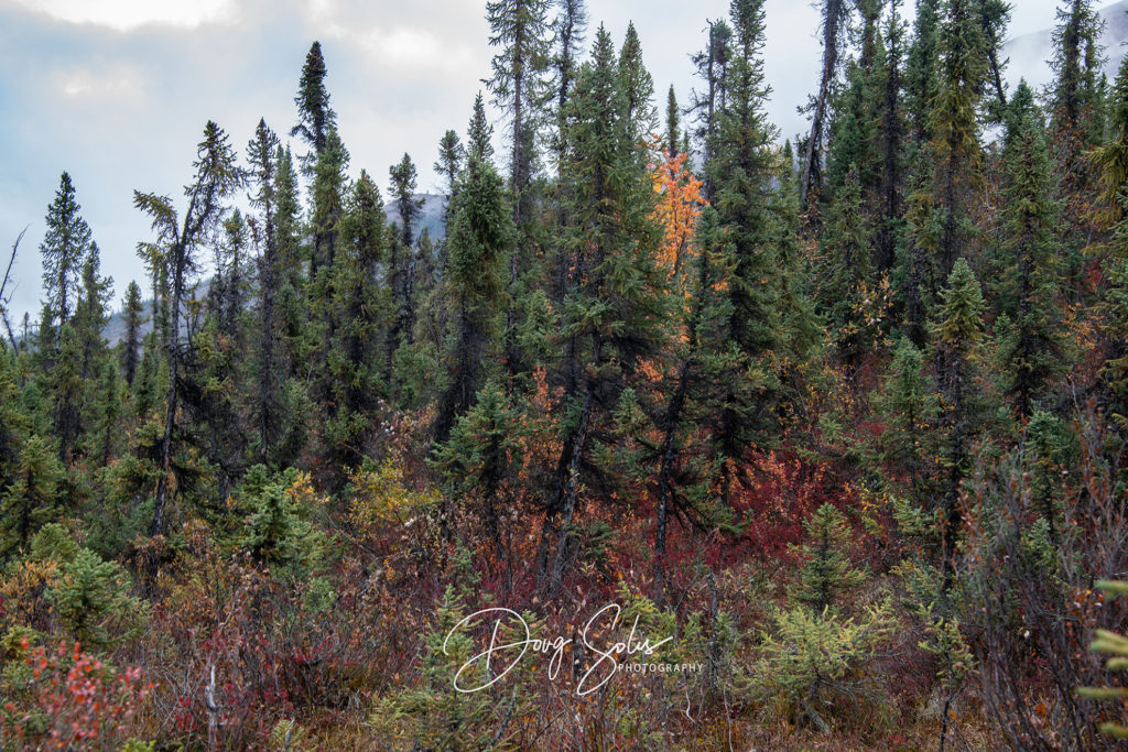
We started out and quickly understood what they were talking about. If you have never walked on tundra before, it’s a wonderful experience at first, almost like walking on a field of soft pillows, but you soon realize that even though it is heavenly soft, it quickly begins to feel like you are on a Stairmaster, one deep step after another. I took the liberty of attaching a 30 second video done by Cindy Conlin that gives you a good visual representation of the joys of tundra walking. Walking on Tundra. Turns out things were going to get a lot tougher. Within the first 300 feet the ground was becoming very boggy and the lichens, moss and flowering cushion plants were quickly being replaced with Tussocks, which would soon become the bane of our existence!

Jena Whipking
They are 2’ knobs of soil topped with grasses, the size of a dinner plate. I swear each plant must have been attached to the earth with a coil spring. You can walk on them if you step in the dead center, but if you are a bit off-center the spring bends and your hopping or flopping towards the next one. You can opt to walk in between each of them and hope the boggy water doesn’t go over your boot (which it will) or just resign yourself to the notion you are going to tussock hop and then flop! The good thing is you are not going to hurt yourself when you fall even with a 64 lb. pack; it just wrenches soooo much energy out of you each time you pull yourself back upright that it is exhausting. Then throw in intertwined willows with spruce and alder trees trees and your only way through is to crawl. Believe me we were close to calling Uber for a ride back home!
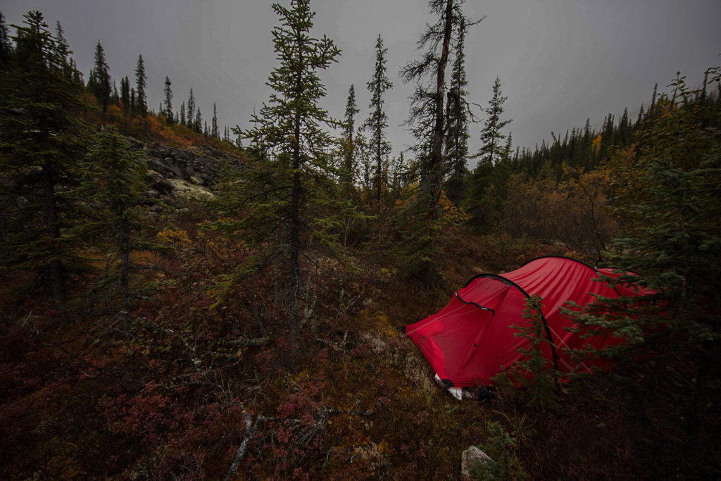
To give you an idea of the break-neck speed we were moving, it literally took us four hours to go 1.2 miles. I kid you not! We were losing light fast but thankfully we finally found a mostly downhill but “dry” 12’ x 6’ area that with a little manicuring we were able to pitch our tent, crawl inside and pass out!
Day 2
The next morning we woke around 5am to the wonderful sound of rain, thank God we could sleep in, and sleep in we did, we didn’t wake up again until nearly 10am. With only a slight drizzle, we prepared breakfast and packed up our gear and once again began to make our way through more of the boggy, marshy, swampy, sodden, crappy backpacking you could imagine. We decided to add some elevation to our slog to see if we could find a drier environment, which did pay off. There still was considerable bushwhacking and talus walking, but not dealing with the Tussocks was a psychological and physical blessing.
We hiked in a Northwesterly direction towards the Arrigetch Creek which leads directly up the valley. We knew we would run into the creek but crossing the trail was not guaranteed. As it turned out the trail was East of us, below us a few hundred feet. Sure enough after about 6 hours of tireless hiking we found the trail, Yahoo! We decided at this point to continue hiking up the trail all the while looking for a good flat area to pitch out tent and get some food in us. At about mile 4 from Circle Lake we found a great area to set up camp.
Day 3
The next morning, we once again slept in until around 10am, the hell with shooting sunrise right! Actually we knew that we were at the bottom of the ravine with only a creek to shoot so it was an easy sleep in decision. Now that we were on “the trail” it felt like we were walking on a freeway. At around mile 5 into the trip, we had our first sighting of the Arrigetch Peaks!
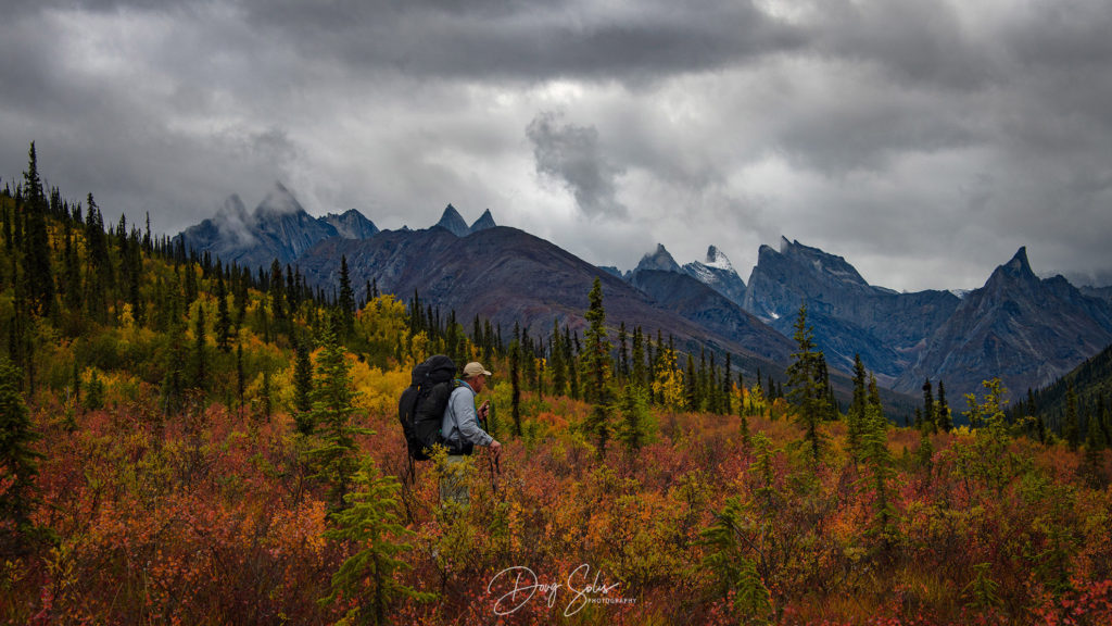
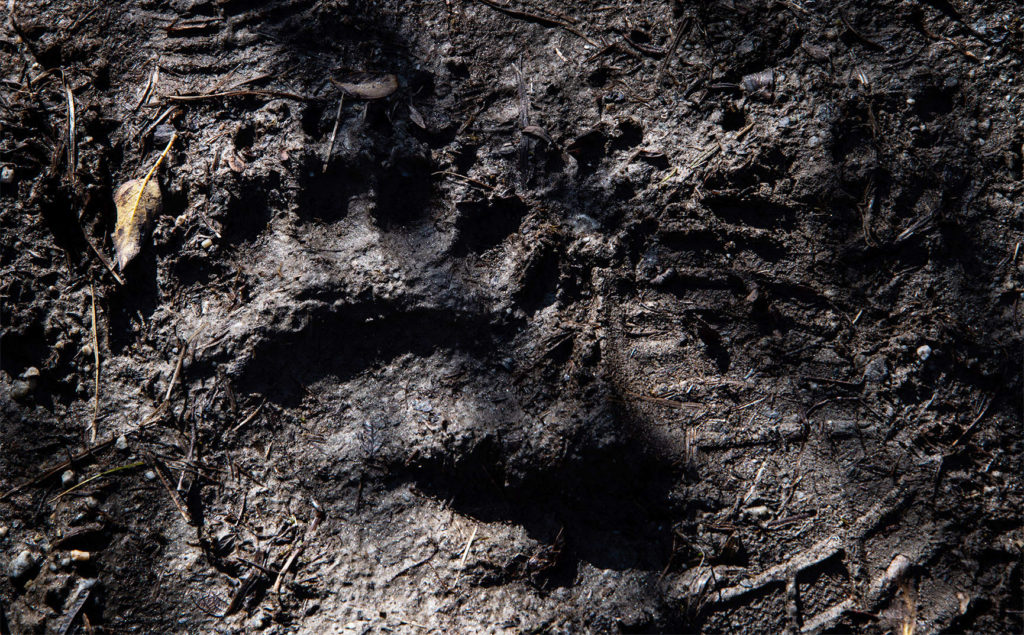
We hiked the next 3 miles in very short order and were close to our proposed base-camp area when we walked through a fresh but empty camp laid out directly on the trail, In the next pic you see why this may not be the best idea given it’s the same trail the bears use! We met up the human residents the next day breaking camp, thankfully they all had survived!
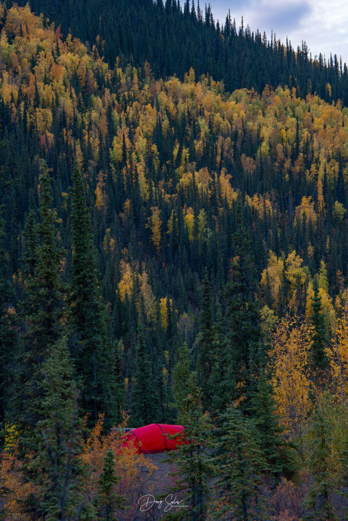
Walking ahead a half mile Jeff found a slight trail to an elevated knoll that turned out to have wonderful views and some much needed semi-flat ground to pitch our tent which would be our home for the next 6 days.
Gates of the Arctic Part II Coming Soon……
Hiking & photography in Aquarius Valley, Valley of the Maidens and Arrigetch Valley.